Tsubunuma Trailhead
・Located right beside Route 397. (A large parking lot is nearby.)
・Compared to the Nakanuma Course, the hiking course is longer.
or from the Oshu Smart IC, head north on Prefectural Route 236,
then west on National Route 397. After passing Isawa Dam, about 3 minutes later you will see a sign for "Kurikoma Yakeishi Hotto Line." Turn left there.
Proceed a little further and you will find a parking lot on the left.
The distance from Mizusawa IC or Oshu Smart IC to the trailhead is about 30 km, taking about 45 minutes.
・If using the JR Tohoku Line: Get off at Mizusawa Station and take a taxi.
*Please arrange your own taxi reservation in advance.
*For reservations regarding shuttle buses from Mizusawa Station or Mizusawa-Esashi Station to Yakeishi Kur park Himekayu, please contact the Yakeishi Kur park Himekayu front desk.
(TEL:0197-49-2006)
・Compared to the Nakanuma Course, the hiking course is longer.
Access
By Car
From the Tohoku Jukan Expressway's Mizusawa IC, head south on Route 4,or from the Oshu Smart IC, head north on Prefectural Route 236,
then west on National Route 397. After passing Isawa Dam, about 3 minutes later you will see a sign for "Kurikoma Yakeishi Hotto Line." Turn left there.
Proceed a little further and you will find a parking lot on the left.
The distance from Mizusawa IC or Oshu Smart IC to the trailhead is about 30 km, taking about 45 minutes.
By Public Transportation
・If using the JR Tohoku Shinkansen: Get off at Mizusawa-Esashi Station and take a taxi.・If using the JR Tohoku Line: Get off at Mizusawa Station and take a taxi.
(1)Taxi fare from the station to Tsubunuma Trailhead (approximate)
| Departure | Duration | Standard-Size Taxi Fare (up to 4 people) |
Large-Size Taxi Fare (up to 9 people) |
|---|---|---|---|
| Mizusawa-Esashi Station | 1hr | 10,000 to 11,000 yen | 16,000 to 17,000 yen |
| Mizusawa Station | 50mins | 8,500 to 9,500 yen | 13,500 to 14,500 yen |
(2)Taxi fare from the nearest lodging to Mt. Yakeishi (approximate)
| Taxi fare from Yakeishi Kur park Himekayu | |
|---|---|
| Standard-Size Taxi Fare | Large-Size Taxi Fare |
| JPY 2,500 to JPY 3,500 | JPY 4,500 to JPY 5,500 |
*Please arrange your own taxi reservation in advance.
*For reservations regarding shuttle buses from Mizusawa Station or Mizusawa-Esashi Station to Yakeishi Kur park Himekayu, please contact the Yakeishi Kur park Himekayu front desk.
(TEL:0197-49-2006)
Location of the parking lot
Surroundings of the Trailhead (Google Street View)
Surroundings of the Parking Lot (Google Street View)
The Path to the Summit
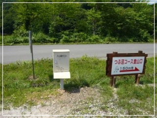
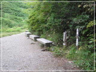
Signboard at Tsubunuma Trailhead parking lot
About 100 parking spaces and toilets are available.
The trailhead is about 180m walk toward Route 397.
About 100 parking spaces and toilets are available.
The trailhead is about 180m walk toward Route 397.
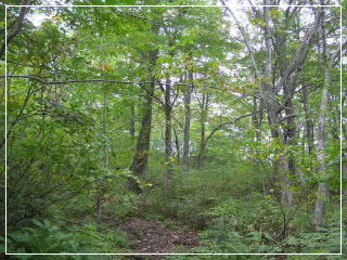
The Tsubunuma Course continues through beech forest until the junction with the Nakanuma Course.
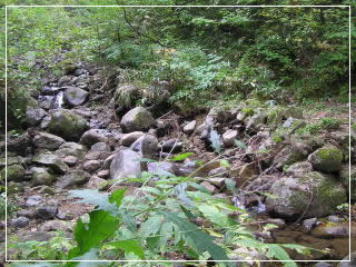
Kanayamasawa stream (about 1 hour from trailhead)
Since you cross a stream, caution is needed during rainy days or when water levels are high.
Since you cross a stream, caution is needed during rainy days or when water levels are high.
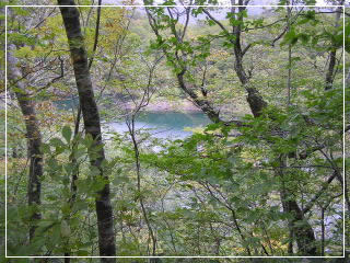
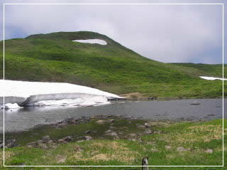
Lake Ishinuma (about 1 hour 40 minutes from trailhead)
Ginmeisui spring (about 2 hours 50 minutes from trailhead)
Around here, the course merges with the Nakanuma Course.
Around here, the course merges with the Nakanuma Course.
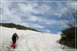
This is the Great Snow Valley, located a little further on from Ginmeisui.
You can see lingering snow until around late July.
You can see lingering snow until around late July.
Lake Sensuinuma(About 4hours and 20 minutes from trailhead)
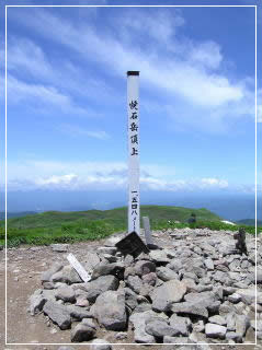
The summit(About 4hours and 40 minutes from trailhead)